Visible Oil Spill DOUBLES in Last Week – 15 June Update
June 18, 2010
I’ve started to summarize the Gulf offshore ocean current data from the oil spil for information while I update Blog readers on BP’s online marketing efforts. This data comes from Roffer’s Ocean Fishing Forecasting Service and is provided free as a public service. Any re-use of the data, please give a strong plug to the great folks at Roffer’s.
To summarize:
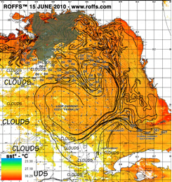
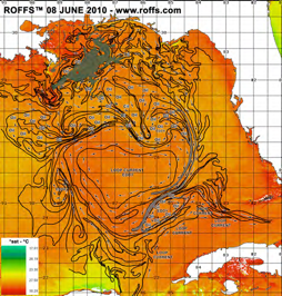
- The visible size of the spill is twice as large as a week ago, compare the two figures below! The area of heavy oil close to the Louisiana marshes is MUCH BIGGER AND MUCH CLOSER TO SHORE than a week ago
- Oil has spread from the Alabama coastline to an area east of Destin Fl (in one week)
- Roffer’s predicts further eastward spread to Port St. Joe and then southward over the Florida West Coast Continental Shelf (some oil is already here)
- Diluted oil/water mixture has moved eastward to the Dry Tortugas
- For now, most of the oil is stuck in the Loop Current eddy west of Florida, called “Franklin”
- A major “Unknown” is whether sizable amounts of oil will be pulled into the main Loop Current and into the Florida Keys. This will take weeks to develop if it happens at all
Figure 1 -15 June Roffer’s Oil Spill Data Update
Figure 2: 8 June Roffer’s Oil Spill Data Update


